THE NATURAL ENVIRONMENT
Geography 101
ToC
EARTH
Geomorph
Interior
Plates
History
Hot Spots
Plate Tectonics
|
|
BOX 1 |
One of the greatest advances in earth science over the past century has been the recognition of plate tectonics. It revolutionized geology and provided a framework for understanding the location of Earth's largest features.
The idea is so obvious to us now that one wonders why it had not been proposed earlier. But geologists simply did not have access to the global information base that became available in the latter half of the twentieth century. Especially important to understanding plate tectonics was the acquisition of data showing the surface topography beneath the world's oceans.
Development of a Theory
There had been many theories to account for the obvious map fact that the coastlines of the Americas very closely matched their counterparts on the opposite side of the Atlantic Ocean. Some suggested that a giant meteorite had struck the Earth and cracked open the Atlantic. Others believed that the Moon had been ripped out of the Pacific basin and filling the hole created caused the Atlantic to open. A common belief in the early part of the last century was that the Earth was shrinking as it cooled. Somehow the shrinking had caused the crust to warp and crack into mountain ranges and ocean basins.
It was not until the creation of an ocean floor map, however, compiled by cartographer Marie Tharp from thousands of deep-sea depth soundings, that the true nature of Earth's surface geology was revealed.
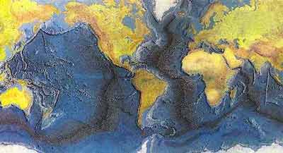
Tharp's map showed long underwater mountain chains, running thousands of miles across the ocean floor. It showed fault lines slicing through these mountains and deep, continuous oceanic trenches along many continental margins. Based on this and other evidence, a theory emerged in the early 1960's suggesting that the outer solid layer of Earth was not static, but moved. The theory suggested that the Americas were moving away from Europe and Africa and that a long mountain range under the central Atlantic was active volcanically, continuously extruding mafic basalt to create new oceanic crust as the Atlantic widened.
 This
theory suggested that the youngest rocks under the Atlantic
Ocean would be found near the
mountains of the mid-Atlantic ridge and that rocks would become progressively older
with distance east and west of the ridge. To test this theory,
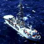
the first ship designed for deep
underwater core sampling, the Glomar Challenger, was dispatched to the
central Atlantic. When analysis of the samples was complete, it
verified that, indeed, rocks increased in age with distance from the ridge. The theory of plate tectonics
became geologic fact.
Today, plate tectonics provides a fundamental and satisfying explanation for a wide range of large features including mountain ranges, fault lines, deep ocean trenches, earthquakes, and volcanoes.
Lithosphere in Motion
Features of the new sea floor map led to the conclusion that long underwater mountain ranges, or mid-oceanic ridges, were centers of sea floor spreading. Here, upwelling of magma from the upper mantle solidifies in the continuous creation of new, basaltic sea floor crust. This new crust is then carried away from the spreading centers by the moving lithosphere. Eventually, the sea floor crust collides with continental margins where it dives down into the mantle to be remelted at subduction zones. Thus, the oldest sea floor crust is found at the farthest distance from a mid-oceanic ridge. The oldest yet sampled, found in the western Pacific, formed 280 million years ago.

The mid-oceanic ridges and subduction zones mark the edges of enormous, moving lithospheric plates, sometimes called tectonic plates. The seven largest plates are named for the continents that ride atop them, with the exception of the Pacific plate. Many smaller plates fill the spaces between these seven massive shells of rock. The map below shows the major plates as well as the locations of sea floor spreading and subduction zones.
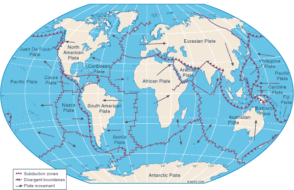
Plate Boundaries
The margins of the plates are very active geologically
and explain the location of most volcanoes and earthquakes. There are
three types of boundaries: divergent (moving apart), convergent (moving
in collision), and transform faults (moving side-by-side).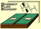
At divergent boundaries, the plates are moving apart, usually in the ocean basins at areas of sea-floor spreading. As noted above, upwelling magma at these spreading centers creates active underwater mountain ranges called mid-oceanic ridges. An example would be the mid-Atlantic ridge.
At many continental margins, plates collide at convergent
plate boundaries.
When a lithospheric plate carrying oceanic crust slams into a plate
carrying continental crust, the higher-density oceanic crust dives
beneath the lighter continental
crust.
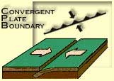 This
type of collision forms a subduction zone and
may produce very deep
ocean trenches. An example of oceanic-continental crust collision
would be of the west coast of North America, where the small oceanic Juan de
Fuca plate
dives beneath the continental North American plate, pushing up the Cascade mountain
range and driving the active Cascade volcanoes.
Other collisions occur between two plates carrying continental crust or two plates carrying oceanic crust. The most dramatic topography results from the thick, buoyant continental-continental crust collisions. The light crust on both plates resists being pushed downward and massive deformation and uplift occurs. An example of continental-continental crust convergence would be the Himalayan mountains forming where the India plate is colliding with the Eurasia plate. At oceanic-oceanic crust convergence, the older, denser plate will subduct. An example is the older Pacific plate diving beneath the younger Philippine plate to form the Marianas Trench, the deepest oceanic location on Earth.
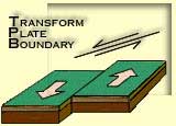 A
final type of boundary occurs where two plates simply slide past
each other forming a fault line. The San Andreas fault
of southern California is a famous example of this kind of transform
plate boundary. Plate boundaries and the landforms they generate
will be discussed further in the next chapter.
What kind of force can make a 80 kilometer (50 mile thick), 25 million square kilometers (10 million sq mi) slab of solid rock slide across the surface? Geologists aren't certain, but the prevailing theory is that mantle convection currents, analogous to the atmospheric Hadley cell or boiling water, causes the motion. Hot magma rises in areas of sea floor spreading and cooler material sinks back down into the mantle in subduction zones forming a huge, slow moving, circulation cell, as shown in the sea floor spreading diagram above.
Interestingly, Earth is the only planet that exhibits rigid plate tectonics. Once again, it appears that our planetary neighbors are either too hot (Venus) or too cold (Mars).