THE NATURAL ENVIRONMENT
Geography 101
ToC
EARTH
Geomorph
Interior
Plates
History
Hot Spots
History of Plate Movement
|
|
BOX 1 |
As noted in the previous section, the huge lithospheric plates that encase the planet are in constant motion, carrying the familiar continents along as passive passengers. The motion is slow, with a maximum of about 12 cm (5 inches) per year, but over millions of years that creeping pace can amount to thousands of kilometers. As a result, the continents are continuously changing position.
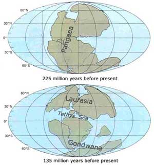
For the past 500 million years, the total area of continental crust has been fairly constant, perhaps increasing slightly. While the overall area has not changed, the configuration and location of the continental masses has changed constantly. Scientists have been able to extrapolate backwards in time to infer how the continents probably moved over the past few hundred million years. The results suggest that about 225 million years ago (mya) all of the continents had crunched together in one gigantic landmass, which has been called Pangaea.
By 135 mya, Pangaea had broken into the northern continental mass of Laurasia and southern continental mass Gondwana. This was a critical time in mammalian evolution as they were diversifying from their egg-laying ancestors. Subsequently, marsupials arose in Gondwana and spread throughout the southern continents of Australia, Africa, South America, and Antarctica, while placentals apparently developed in tropical Laurasia. As noted earlier, placental mammals never had the opportunity to colonize Australia as it broke away from Gondwana and drifted through the southern ocean in isolation.
 |
 |
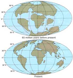
By 65 mya, the continents had moved into a more recognizable arrangement. India moved toward Asia, Australia continued eastward, Antarctica (once home to marsupials) became centered on the South Pole, and the Americas were separating from Africa and Eurasia.
Africa alone, of all the continents, has remained in approximately the same relative position for the past 200 million years as the other continents pulled away. Many features of the African landmass today, such as huge interior basins filled with sediment and erratic river courses, are relics of a time when it lay at the center of giant Pangaea.

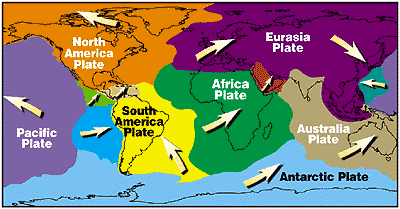
Today, the continents continue to move, carried along by their underlying lithospheric plates as shown in the diagram. Notice that the Pacific and Eurasia plates are converging from opposite directions, colliding in the Western Pacific. This collision has formed long island arcs (lines of volcanic islands forming at collision boundaries) in the western Pacific, including the islands of Japan and the Philippines. The Atlantic Ocean is widening and the Pacific Ocean is shrinking. South America is colliding with the Nazca plate (in bright blue) pushing up the Andes mountains. The Australian plate collides with the Eurasia plate forming another island arc, the main islands of Indonesia. Notice that the Pacific plate is moving to the northwest in the Hawaiian Islands area.
And before Pangaea? Apparently the continents have coalesced and separated many times in Earth's history. About 400 million years ago, for example, most of the continents were located in the southern hemisphere, the opposite of what we see today. Through all of these position changes, the total land area of the continents has remained approximately the same.