THE NATURAL ENVIRONMENT
Geography 101
ToC
MOUNTAINS
Crust
Folding
Earthquakes
Volcanoes
Hawai'i
Folding and Faulting
|
|
BOX 1 |
Rock is a plastic material that endogenic processes mold into the wrinkled, deformed surface of our planet. Movements of lithospheric plates, which generate tension and compression in the crust, cause most of the large-scale shaping.
Compression
When
endogenic forces squeeze
rock in compression, it does not immediately
fracture, but deforms extremely slowly. Because it
can deform without breaking, large masses of solid rock are said to be plastic under
pressure. The most dramatic example of this occurs when two tectonic
plates carrying continental crust collide, as shown in the diagram.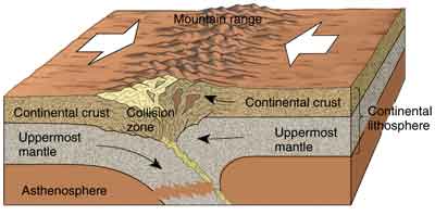
This
mechanical process is best illustrated today by the collision of the
Eurasia and India plates, which crumple together under
the Himalaya
mountain range. The Himalayas are newly formed mountains and still growing
at about two millimeters per year. Older mountain ranges, such as the
Atlas Mountains in
Africa and the Alps in Europe are the result of plate collisions occurring
further back in geologic time.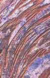
Lithospheric
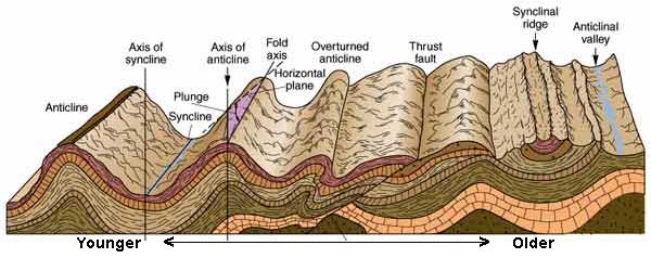
plate compression produces a standard sequence of rock folding and faulting,
as shown in the diagram below. First, anticlinal (upward)
and synclinal (downward) folds appear. As the folding
becomes more extreme, the rock layers will eventually shear along a thrust
fault. Areas shaped by this process are often
called
fold and thrust topography.  Eventually,
erosion will smooth the topography leaving remnant synclinal
ridges and anticlinal valleys.
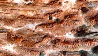
As time wears on and the compression forces diminish, erosion produces a series of rounded, parallel valleys and ridges, such as the Appalachian Mountains in the Eastern United States as shown in the satellite image of central Pennsylvania.
Tension
When a large mass of rock breaks, it fractures along a fault plane. You can visualize this by rubbing two books together. The surface where the books touch is equivalent to a fault plane and the relative movement of the books illustrates the movement of rock masses on opposite sides of the fault plane.
 As
noted above, compression can produce faulting in rocks in the form of
thrust faults. Tension also produces faulting. A common configuration
that results from tension forces is the formation of parallel horsts and grabens. As the rock mass pulls apart,
it fractures along a series of fault planes where blocks of rock sink
downward by gravity, producing long, linear valleys (grabens) and mountain
ranges (horsts). Part of the fault plane itself becomes exposed, forming
a fault scarp.
This configuration occurs when an area in the interior of a lithospheric plate bends upward, cracking the surface rock in a series of fault planes and forming parallel horsts and grabens.
Geologists call this formation basin and range topography, in which the basins are grabens partially filled in with sediment and the ranges are horsts worn down by erosion. Much of the state of Nevada consists of this type of surface relief. The Zargos Mountains in Iran, shown in the image, are another example. Can you see the sculpted mountain ranges and smooth valley basins in the image?
 Tensional
faulting also occurs when areas of continental crust separate along
faults in the underlying lithospheric
plate.
This
forms long, linear grabens called rift
valleys. Africa's
Great Rift Valley system, for example, consists of 5000 kilometers (3100 miles) of grabens
being formed as the continent of Africa splits
apart.
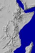
  In
the satellite image composite, you can see the series of rift valleys being
formed as the eastern portion of Africa, including the
"Horn" feature, is slowly moving eastward and breaking away
from the main mass of the African continent.
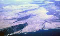
The photo shows the Rift Valley floor (a large graben) and associated fault scarp. Eventually the valley floor will sink below sea level and become a long narrow extension of the Red Sea.
Hilina Pali Fault System
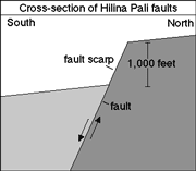
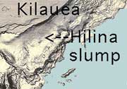
While the Hawaiian Islands do not experience the huge tectonic forces exerted on continental landmasses, they do experience significant faulting. Particularly obvious are the faults along the southern flank of Kilauea volcano, on the Big Island, called the Hilina Pali Fault System. Anyone who has driven down to see the active lava flow at the end of Chain of Craters road in Volcanoes National Park has driven down the face of a Hilina Pali fault scarp. The southern part of Kilauea is slowly slumping downward into the ocean along a series of fault planes. Slipping along these faults causes many of the large Big Island earthquakes (discussed in the next section) and helps explain the occurrence of gigantic Hawaiian landslides (also discussed in the next chapter).
 |
 |
 |
Figures from US Geologic Survey |
||