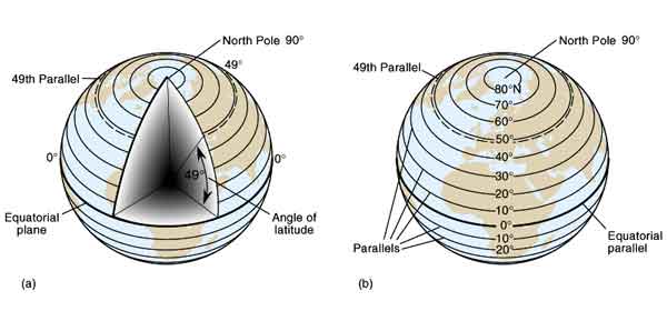
The geographic grid refers to the spherical coordinate system of latitude and longitude used to location positions uniquely anywhere on the surface of the earth. These coordinates are given as angles, rather than distances used in more familiar rectangular coordinate systems. Latitude is the spherical angle north or south of the Equator with a vertex at the center of the earth (see diagram). Latitude values range from 0° at the Equator to 90° North at the North Pole and 90° South at the South Pole. All latitude lines form complete circles, which are also called parallels. Equator, North Pole, and South Pole are names of specific parallels of latitude. The latitude grid is illustrated below.
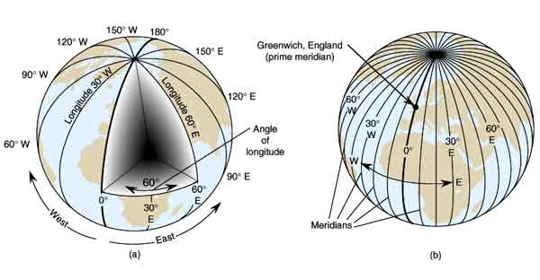
Longitude lines, also called meridians, are defined as the spherical angle east or west of Greenwich, England, location of the Prime Meridian of 0° longitude. Longitude values increase from 0° at Greenwich westward through the western hemisphere to 180° and eastward through the eastern hemisphere to 180° as shown in the diagram. 180° longitude lies on the opposite side of the earth from Greenwich and is known as the International Date Line for reasons discussed in the Time Zone section of this lab. The International Date Line and the Prime Meridian are names of specific meridians of longitude. The longitude grid is illustrated below.
Geographic coordinates, then, are latitude-longitude pairs. The latitude is always given first and the longitude second. Latitude will almost always include an N (for North of the equator) or S (for South of the equator) and longitude will almost always include an E (for East of Greenwich) or W (for West of Greenwich). Exceptions are 0° latitude and 0° and 180° longitude, which do not have a letter attached to them.

Identify the approximate latitude and longitude of the following places using the map. Coordinates to the nearest 5 degrees are adequate for this exercise.
|
LOCATION 1. Greenwich England (red dot) |
LATITUDE _______________ |
N/S |
LONGITUDE |
E/W |
Practice finding differences in latitude and longitude between places (use smallest longitude difference):
8. ________ Approximately how many degrees latitude difference between Greenwich and Hawaii?
9.
________ Approximately how many degrees latitude difference between Cape of Good Hope and
Siberia?
10. _______ Approximately how many degrees latitude difference between Amazon and West Antarctic
Ice Sheet?
11. _______ Approximately how many degrees longitude difference between Borneo and Hawaii?
12. _______ Approximately how many degrees longitude difference between Greenwich and Cape
of Good Hope?
13. _______ Approximately how many degrees latitude difference between Greenwich and West
Antarctic Ice Sheet?
14. _______ Approximately how many degrees longitude difference between Hawaii and Greenwich?
15. _______ Approximately how many degrees longitude difference between West Antarctic
Ice Sheet and Siberia?
Practice finding new latitude and longitudes when moving across the surface of the earth. I recommend using a pointer, like your finger, to trace the move. Put it on the starting coordinate and then move it the distance and direction noted in the question. In the first example, put your finger on 30° N anywhere on the map, then move your finger downward (South) through 20° of latitude. Now read the new latitude using the labels at the side of the map.
16. _____ If you start at 30° N and move 20° southward, what is your new latitude?
17. _____ If you start at 60° N and move 25° northward, what is your new latitude?
18. _____ If you start at 50° S and move 60° northward, what is your new latitude?
19. _____ If you start at 30° N and move 100° southward, what is your new latitude?
20. _____ If you start at 20° W and move 50° westward, what is your new longitude?
21. _____ If you start at 150° E and move 30° westward, what is your new longitude?
22. _____ If you start at 30° W and move 40° eastward, what is your new longitude?
23. _____ If you start at 150° W and move 80° westward, what is your new longitude?