Selected Past and Ongoing Research Projects
Water- and Eath-associated Alterations on the Moon
Read the press release of this work here and here.
Observations of lunar surface water (OH/H2O) and water ice led me to assess possible evidence for water rock reactions on the Moon. Hematite is a common product of water rock reactions on Earth, Mars, and some asteroids. It is also an excellent ferric target for remote detection using visible to near infrared (VNIR) spectroscopy because of its unique spectral properties relative to common lunar materials. There are no unambiguous detections of ferric minerals both in sample analyses and remote observations on the Moon. I analyzed M3 data and found that hematite is present at high latitudes on the Moon [Li et al., 2020, Science Advances], mostly associated with east-equator facing sides of topographic highs, and is more prevalent on the nearside than the far side. My results suggest that oxygen delivered from Earth's upper atmosphere could be the major oxidant that forms lunar hematite. Future oxygen isotope measurements can test this hypothesis and may help to reveal the evolution of Earth's atmosphere. The orbital detection of widespread hematite at high latitudes suggests that the lunar polar regions are much more chemically reactive than the equatorial region, particularly under the presence of water. Future studies focusing on the polar regions to fill our knowledge gap about possible chemical processes are critical for the future robotic and human being landings in the lunar polar regions.

![]()
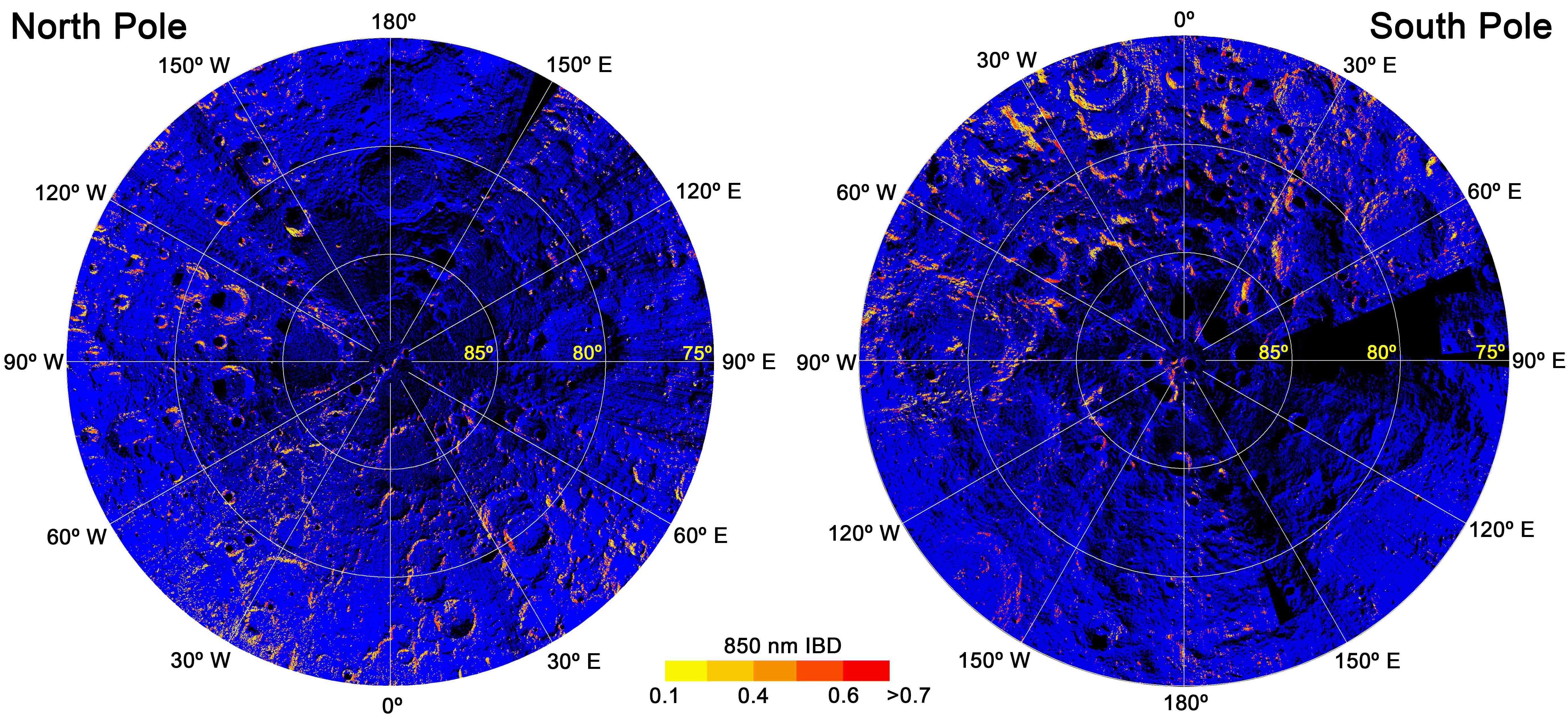
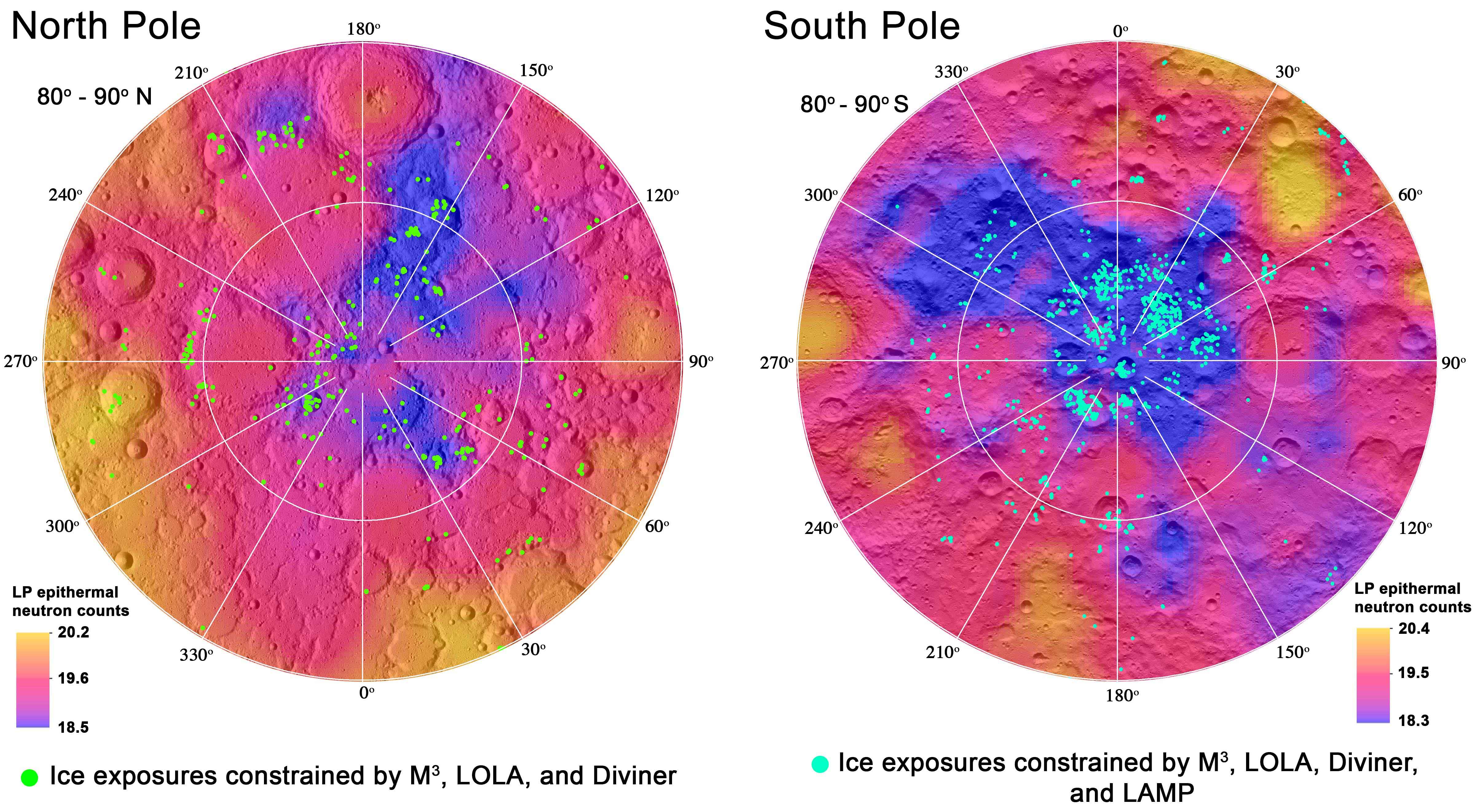
Surface Water Ice in the Lunar Polar Region
Read the story behind this project at Scientific American.
Temperature assessments by the LRO Diviner radiometer showed that permanently shaded regions (PSRs) in the lunar polar regions are cold enough (i.e. < 110 K) to allow accumulation of water over time. However, evidence of surface exposed water ice on the lunar surface had remained elusive. My observations of the diurnal variation of the lunar surface water inspired me to assess any of such water would have migrated to and then sequestered in PSRs. I worked with multiple orbital datasets near the lunar poles to exploit signatures of the surface exposed water ice. Water ice has unique absorption features near 1.3, 1.5, and 2.0 μm in the near infrared region. I applied these three absorptions as criteria to exploit M3 data in the shaded regions illuminated by stray light near the poles to seek evidence for the presence of ice. I found that only around 5% of cold traps at both lunar poles show infrared signatures of ice. These ice bearing pixels show temperature < 110 K, high LOLA albedo, and high band ratios of LAMP data, which supports my findings of surface exposed ice. My work is the first report of definitive evidence for the surface exposed water ice on the Moon [Li et al., 2018, PNAS]. These ice deposits can be important in situ resources for future exploration of the Moon.
The ice locations shown in Fig.4 in the Li et al., 2018 PNAS paper are available upon request.

Water on the Moon: Distribution, Variation, and Origins
Water is one of the most volatile species during the formation and evolution of the Moon. The distribution and variation of water on the Moon can provide clues about processes of formation/transportation, retention, and sequestration, which helps to unveil how the Moon formed and evolves. One of my previous work focused on understanding the distribution, variation, and origins of “water” (OH or H2O) on the Moon. My research combined the reflectance data acquired by the Moon Mineralogy Mapper (M3) onboard the Chandrayaan-1 mission, thermal infrared measurements from the LRO Diviner instrument, and lab spectra of Apollo and Luna samples to develop a novel empirical thermal correction model for M3 data [Li and Milliken, 2016]. The resulting thermally-corrected M3 data, combined with models grounded in lab experiments, enabled me to quantitatively map the spatial and temporal variations of lunar surface water at a global scale.
Key findings of this work were that: 1) lunar surface water is variable both spatially and temporally [Li and Milliken, 2017]. The distribution and abundance of lunar surface water increases with latitude, from <100 ppm at the equatorial region to ~1000 ppm at the poles. The diurnal variation of surface water is manifest mostly at latitudes less than about 65° north and south, while higher latitudes are characterized by higher water content and stability. 2) A Strong correlation between the water content and the surface exposure time was observed at latitudes >~30°N/S, possibly indicating the accumulation of water in agglutinate glass through geologic time. 3) Localized water anomalies were observed in most pyroclastic deposits and some silicic rich domes, suggesting a lunar interior origin [Li and Milliken, 2017; Milliken and Li, 2017]. 4) My results showed that high-Ti pyroclastic deposits show higher water content than low-Ti ones, indicating either different water contents in magma sources, different degassing history, or both.
This work reports the first quantitative map of lunar surface water at a global scale and stimulates research on understanding the interactions of solar wind with the lunar soil. It also provides a broader picture of magma volatile content and variations in magma degassing history on the Moon. My quantitative map of lunar surface water provides a roadmap for exploring water as in situ resources on the Moon.
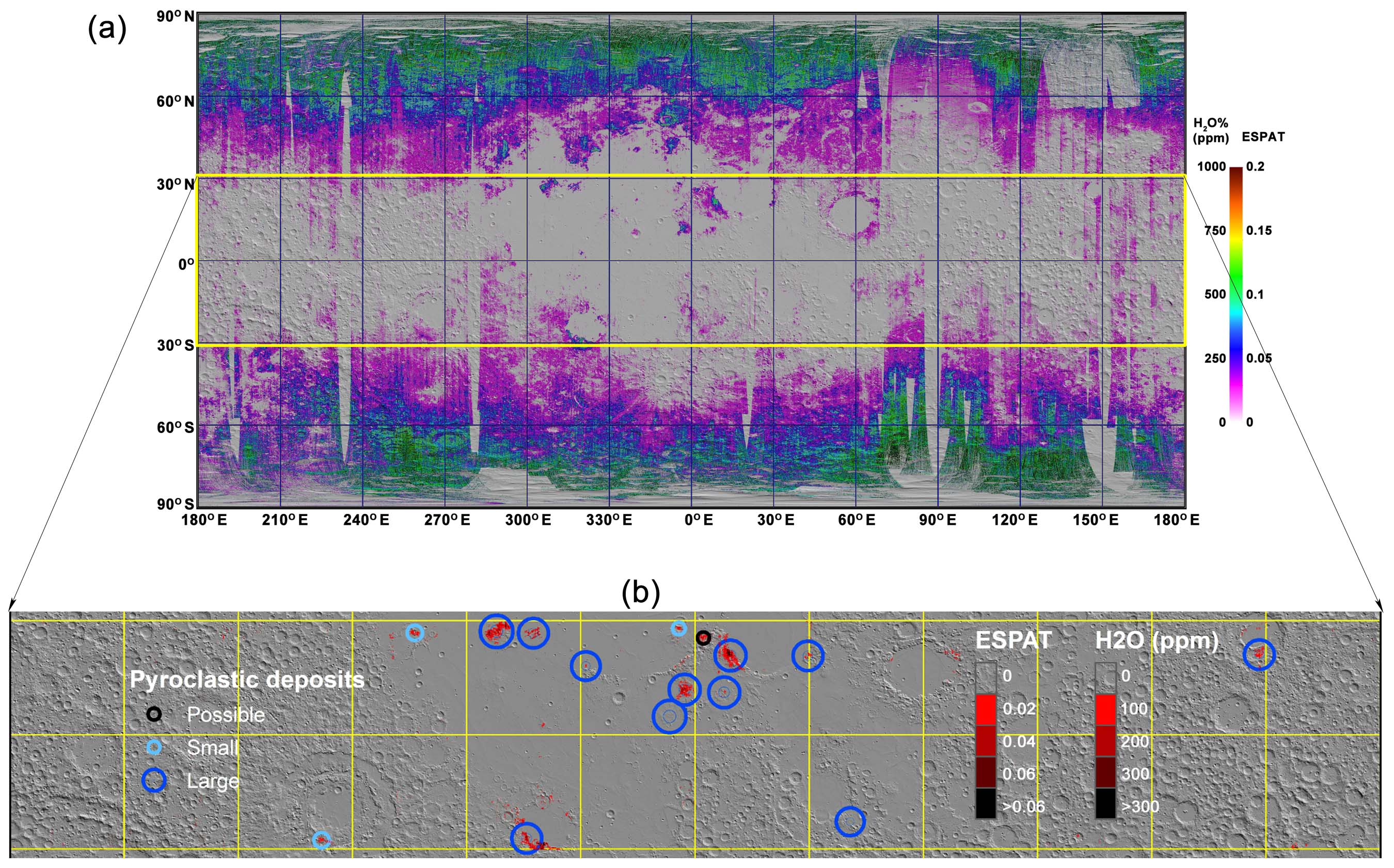
Read more at Li and Milliken, 2017, Science Adv.; Milliken and Li, 2017, Nature Geo; Li and Garrick‐Bethell, 2019; GRL.
![]()
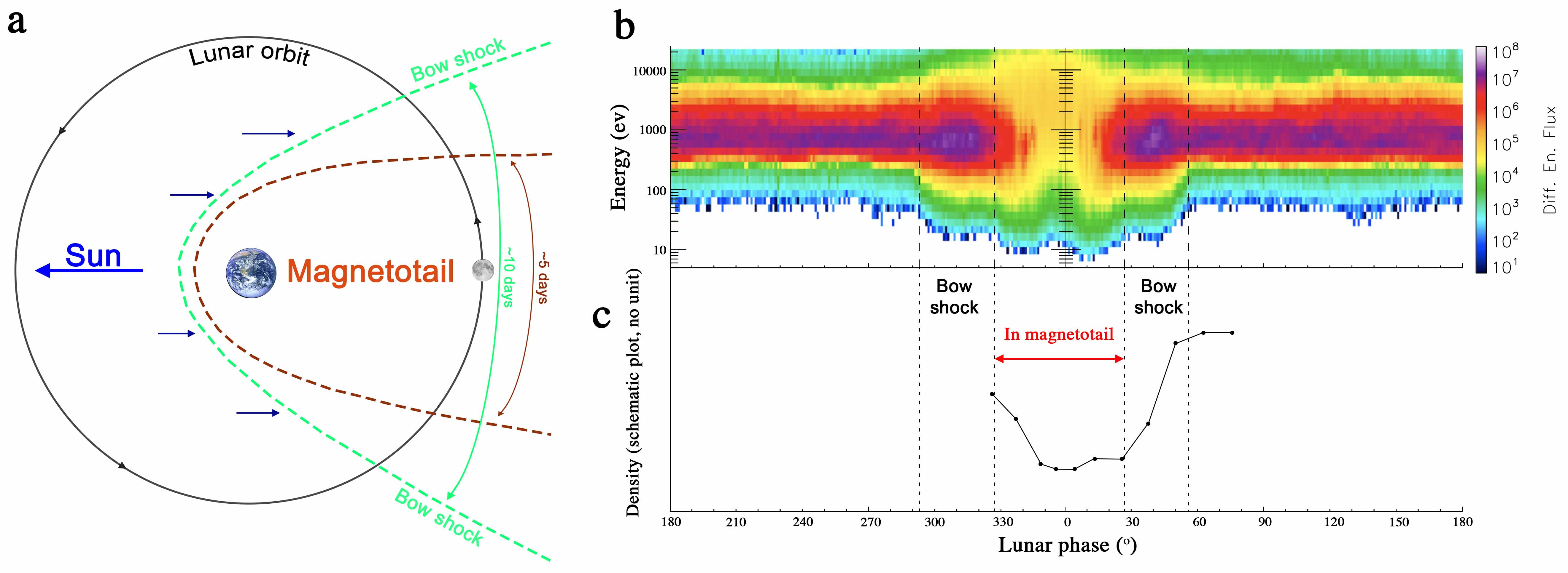
Effects of Earth's Magnetotail on the Foramtion of Lunar Surface Water - Ongoing Research
The temporal (i.e., diurnal) variation of the lunar surface water suggests that the formation of water by solar wind implantation is an instantaneous process (Sunshine et al., 2009; Li and Milliken, 2017; Wöhler et al., 2017). But because the Moon traverses through Earth’s magnetotail in each lunar day, the magnetotail can significantly reduce the flux of solar wind hydrogen hitting the lunar surface (e.g., Poppe et al., 2017). Thus, less water is predicted to be present at locations in the magnetotail that repels solar wind hydrogen. However, the Lyman Alpha Mapping Project (LAMP) observations suggest no hydration difference between regions in and out of the magnetotail (Hendrix et al., 2019). We will verify the observations by (Hendrix et al., 2019) with the data acquired by the Moon Mineralogy Mapper (M3) onboard the Indian's Chadrayaan-1 mission. We propose to assess the variation of lunar surface water during the Moon traverses through the magnetotail using M3 data to understand whether the magnetotail shows shielding effects on the formation of lunar surface water.
![]()
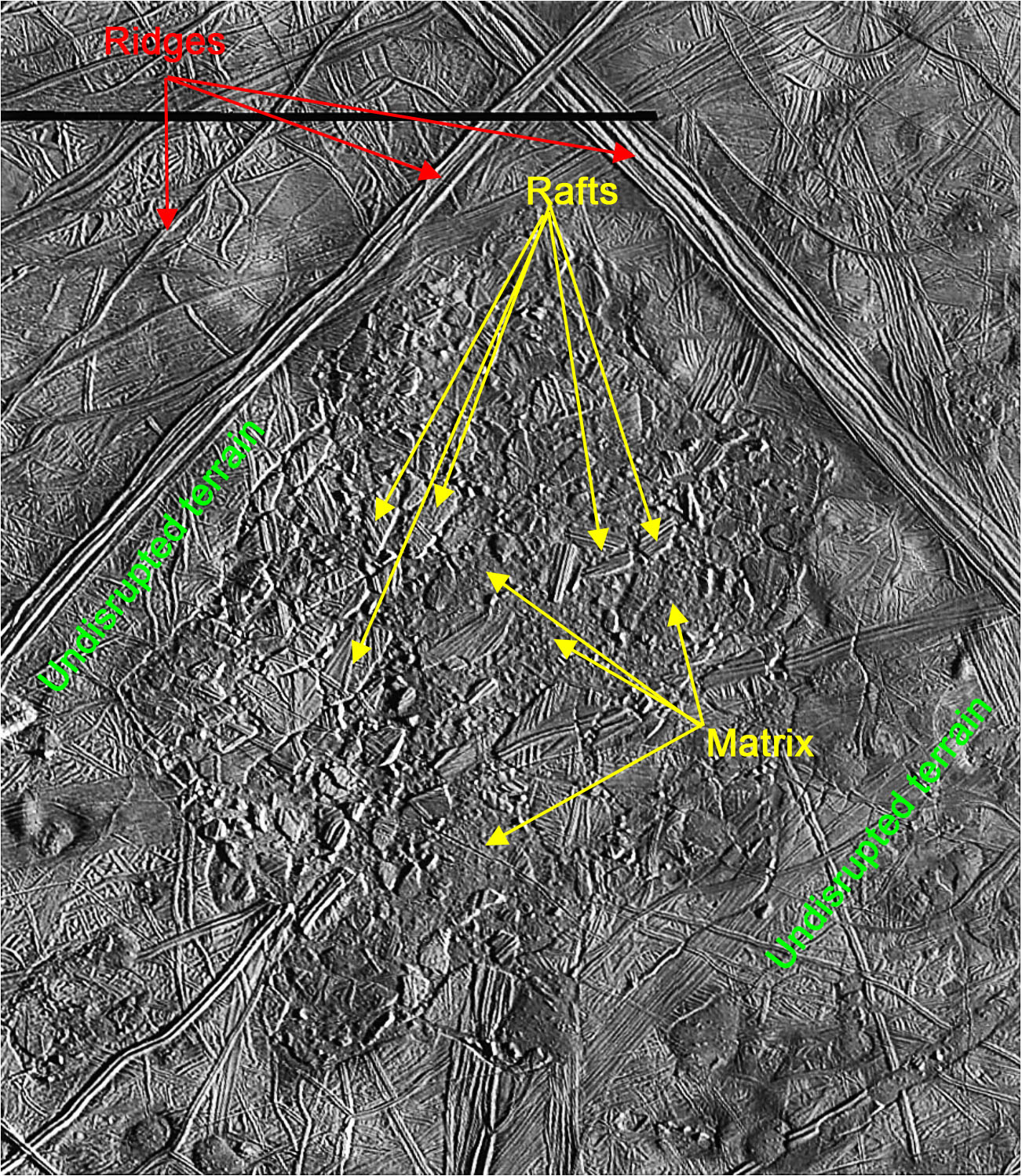
Formation Mechanisms of Chaos Terrain on Europa - Ongoing Research
Chaos terrains on Europa’s surface are disrupted ice shells that are composed of ‘rafts’ (the broken pieces of the shell, Fig. 1), ‘matrix' (the hummocky plains around rafts, Fig. 1), and show clear boundaries with surrounding undisrupted terrains (Fig. 1). It is unclear how these chaos terrains are formed. However, two popular hypotheses propose that: 1) they form from re-solidification of the ice shell that has been melted through by the interior thermal activities (‘melt through model’); or 2) they are collapsed ice shells due to brine mobilization (‘brine mobilization model’). Both models predict that the composition of rafts should resemble that of undisrupted terrains. However, the melt through model suggests that the water ice content along chaos terrain boundaries and matrix should be higher than that of undisrupted terrains (Greenberg et al., 1999), while the brine mobilization model suggests that we should observe higher abundances of brine minerals at chaos terrain boundaries and matrix than undisrupted terrains (Head and Pappalardo, 1999; Schmidt et al., 2011). However, the differences of the water ice and brine mineral contents among different units of chaos terrains were only qualitatively assessed in the two conceptual models (Greenberg et al., 1999; Head and Pappalardo, 1999; Schmidt et al., 2011). Our objective is to test the two models by examining the compositional variations among rafts, matrix, boundaries, and undisrupted terrains. Our hypothesis is that if the melt through model is correct, the water ice content along chaos terrain boundaries and matrix should be higher than that of undisrupted terrains. If the brine mobilization model is true, we should observe higher abundances of brine minerals at chaos terrain boundaries and matrix than undisrupted terrains. While both models predict that the mineral compositions of rafts should resemble those of undisrupted terrains.
![]()